
Of art and nail polish
Identity and asset map for Boston’s Fenway District

Some of the world’s most recognized cultural institutions and public spaces grace a two-mile stretch of Boston’s Huntington Avenue. Here, the Berklee School of Music, the Isabella Stewart Gardner Museum, and the Boston Symphony coexist with a heady knowledge economy and upscale retail. But as a district planning study, led by UK-based placemaking consultant Futurecity, got underway, it quickly became clear that the district, alas, doesn’t see itself as a district.
To convince a roomful of august institutional stakeholders that they shared—literally—common ground, we needed critical distance. We needed perspective. We needed a bird’s-eye view. In other words, we needed a map.
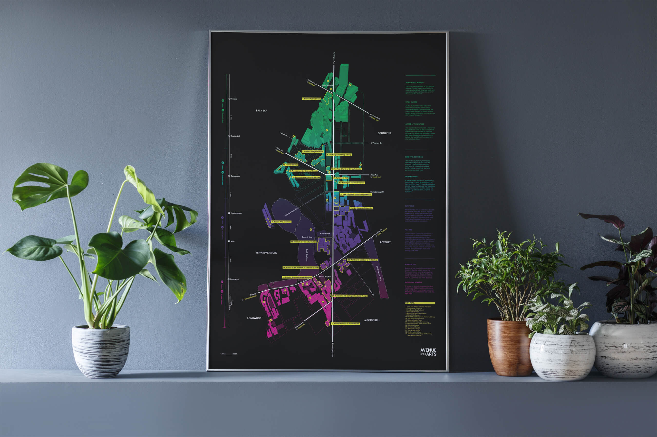
Through a series of charrettes with stakeholders and consultants, we recognized that people don’t view the district as a homogenous entity. Rather, they experience a string of distinct zones, loosely connected together by a central spine—Huntington Avenue. Our map, therefore, reduced visual clutter to foreground the Avenue, a central element that bisects the page. All around it, dramatically plotted against a black background, are interconnected clusters of arts and culture venues. Along one side, we provided walking, biking, and transit information, showing relationships between zones diagrammatically. Along the other, we developed a series of vignettes that cue viewers into the district’s blockbuster cultural attractions, as well as its hidden wonders.
“It will make a beautiful and highly relevant addition to our collection.”
The map not only depicted a journey, but made one. Limited-edition prints were silk-screened by students at MassArt, located at the edge of the district. Print Number One, tucked securely in a tube, travelled to the opposite end of the Avenue, to the doors of the Boston Public Library, where, gently handled by curators’ white-gloved hands, it entered into the institution’s permanent collection. The district, at last, was made visible to itself.


Handmade—Although the map was digitally authored, it was printed by hand: MassArt students poured labor and love into a set of limited-edition silkscreens.
Colophon
Project
Identity and asset map for Boston’s Fenway District
Client
The Boston Foundation and consortium of cultural partners
Typology
Credits
In partnership with FutureCity, printed by MassArt, completed while at Sasaki
Accolades
Winner, PRINT Magazine 2018 Regional Design Award; on permanent collection of the Boston Public Library
Related Work
